In my earlier post on the Mercator projection, I derived the function h(φ) that maps latitude on the Earth to vertical height on a map. The inverse of this function turns out to hold a few surprises.
The height y corresponding to a positive latitude φ is given by
h(φ) = log( sec(φ) + tan(φ) ).
The inverse function, h-1(y) = φ gives the latitude as a function of height. This function is called the “Gudermannian” after Christoph Gudermann and is abbreviated gd(y). Gudermann was the student of one famous mathematician, Karl Friedrich Gauss, and the teacher of another famous mathematician, Karl Weierstrass.
The Gudermannian function gd(y) can be reduced to familiar functions:
gd(y) = arctan( sinh(y) ) = 2 arctan( ey ) – π/2.
That doesn’t look very promising. But here’s the interesting part: the function gd forms a bridge between hyperbolic trig functions and ordinary trig functions.
sin( gd(x) ) = tanh(x)
tan( gd(x) ) = sinh(x)
cos( gd(x) ) = sech(x)
sec( gd(x) ) = cosh(x)
csc( gd(x) ) = coth(x)
cot( gd(x) ) = csch(x)
By definition, gd(x) is an angle θ whose tangent is sinh(x).
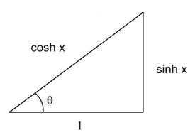
In the figure, tan(θ) = sinh(x). Since cosh2(x) – sinh2(x) = 1, the hypotenuse of the triangle is cosh(x). The identities above follow directly from the figure. For example, sin(θ) = sinh(x) / cosh(x) = tanh(x).
Finally, it is easy to show that gd is the inverse of the Mercator scale function h:
h( gd(x) ) = log( sec( gd(x) ) + tan( gd(x) ) ) = log( cosh(x) + sinh(x) ) = log( ex ) = x.
The gudermanian has another property: its derivative is the secant. That’s no surprise if you know the inverse function theorem, but there’s a nice footnote to this (from Spivak’s “Calculus”, second edition, page 383, problem 19.12), which kind of amplifies what your earlier posting said:
“There is another expression for [the integral of secant], which is … log(tan(x/2 + pi/4)). This last expression was actually the first one discovered, and was due, not to any mathematician’s cleverness, but to a curious historical accident: In 1599 Wright computed nautical tables that amounted to definite integrals of sec. When the first tables for the logarithms of tangents were produced, the correspondence between the two tables was immediately noticed ( but remained unexplained until the invention of calculus). ”
[If your (I’m speaking to everyone here) calculus book didn’t have cool things in it like this, you should pick up a copy of Spivak’s book!]
Spivak’s book is one of my favorites.