I read somewhere that, contrary to popular belief, Kansas is not the flattest state in the US. Instead, Florida is the flattest, and Kansas was several notches further down the list.
(Update: Nevertheless, Kansas is literally flatter than a pancake. Thanks to Andreas Krause for the link in the comments.)
How would you measure the flatness of a geographic region? The simplest approach would be to look at the range of elevation from the highest point to the lowest point, so that’s what I did. Here are elevations and differences for each state, measured in feet.
|----------------+-------+------+-------|
| State          |  High |  Low |  Diff |
|----------------+-------+------+-------|
| Florida        |   345 |    0 |   345 |
| Delaware       |   450 |    0 |   450 |
| Louisiana      |   535 |   -7 |   542 |
| Mississippi    |   807 |    0 |   807 |
| Rhode Island   |   814 |    0 |   814 |
| Indiana        |  1257 |  322 |   935 |
| Illinois       |  1237 |  279 |   958 |
| Ohio           |  1549 |  456 |  1093 |
| Iowa           |  1670 |  479 |  1191 |
| Wisconsin      |  1952 |  581 |  1371 |
| Michigan       |  1982 |  571 |  1411 |
| Missouri       |  1772 |  230 |  1542 |
| Minnesota      |  2303 |  600 |  1703 |
| New Jersey     |  1804 |    0 |  1804 |
| Connecticut    |  2382 |    0 |  2382 |
| Alabama        |  2405 |    0 |  2405 |
| Arkansas       |  2756 |   56 |  2700 |
| North Dakota   |  3507 |  751 |  2756 |
| Pennsylvania   |  3215 |    0 |  3215 |
| Kansas         |  4042 |  679 |  3363 |
| Maryland       |  3363 |    0 |  3363 |
| Massachusetts  |  3491 |    0 |  3491 |
| South Carolina |  3563 |    0 |  3563 |
| Kentucky       |  4144 |  256 |  3888 |
| Vermont        |  4396 |   95 |  4301 |
| Nebraska       |  5427 |  840 |  4587 |
| West Virginia  |  4865 |  240 |  4625 |
| Oklahoma       |  4977 |  289 |  4688 |
| Georgia        |  4787 |    0 |  4787 |
| Maine          |  5269 |    0 |  5269 |
| New York       |  5348 |    0 |  5348 |
| Virginia       |  5732 |    0 |  5732 |
| South Dakota   |  7247 |  968 |  6279 |
| New Hampshire  |  6293 |    0 |  6293 |
| Tennessee      |  6647 |  177 |  6470 |
| North Carolina |  6690 |    0 |  6690 |
| Texas          |  8753 |    0 |  8753 |
| New Mexico     | 13169 | 2844 | 10325 |
| Wyoming        | 13812 | 3100 | 10712 |
| Montana        | 12808 | 1801 | 11007 |
| Colorado       | 14439 | 3314 | 11125 |
| Oregon         | 11247 |    0 | 11247 |
| Utah           | 13527 | 2001 | 11526 |
| Idaho          | 12667 |  712 | 11955 |
| Arizona        | 12631 |   69 | 12562 |
| Nevada         | 13146 |  479 | 12667 |
| Hawaii         | 13806 |    0 | 13806 |
| Washington     | 14419 |    0 | 14419 |
| California     | 14505 | -282 | 14787 |
| Alaska         | 20335 |    0 | 20335 |
|----------------+-------+------+-------|
By the measure used in the table above, Florida is about 10 times flatter than Kansas.
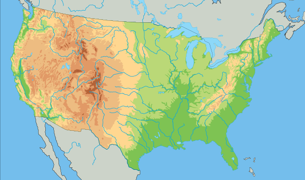
The centroid of the continental US is in Kansas, and if you look at the center of the map above, you’ll see that there’s an elevation change across Kansas.
If I remember correctly, the source I saw said that Kansas was something like 9th, though in the table above it is 20th. Maybe that source measured flatness differently. If you had a grid of measurements throughout each state, you could compute something like a Sobolev norm that accounts for gradients.
One may imagine that the rate at which the elevation changes should somehow be taken into account. An extremely rough area with rapid elevation changes from minimum to maximum, even if those are in a narrow range, would probably not fall into our intuition of flat. Of course, in practice, for large natural geographies in area with erosion, I suspect your method is reasonable.
If I really wanted to compute “flatness” I would try first finding a best-fit ellipsoid for the surface of each state, then comparing the rms residuals. Or something like that, devil in the details.
You don’t have a uniform grid but I bet you could make one with the elevation of every city. That seems to be well documented, although getting the data might be a job for some Wikipedia scraping
What we are colloquially calling “flatness” includes a large measure of bareness. Think of two regions with identical small slopes, one tundra the other dense jungle. We’d call the tundra flat but not the jungle. I think it’s because we’re observing the land from a 2 meter high vantage point upon the land, not from a God’s-eye view. That’s why we’re more likely to describe Kansas as flat than Florida
Variance in elevation would also be a useful measure.
Jonathan has apparently never been to Kansas. There are large areas of the state that have decent hills with considerable erosion, unlike Florida.
Your method doesn’t consider anomalies. One peak can vastly overestimate your values. Much better would be to calculate the differences in each county, weight them by the % of area each county has in the overall state’s area and get a value based on that. That would reduce the effect of one high peak. And in a state like West Virginia, each county would show high relief, and the cumulative effect would greatly reduce their flatness factor. Even better would be to create a grid of squares 10 miles per side and do the above calculations, adjusting for partial squares. But would take a lot of effort, while county data should be readily available.