What point on Earth is farthest from its center? Mt. Everest comes to mind, but its summit is the point highest above sea level, not the point farthest from the center. These are not the same because the Earth is not perfectly spherical.
Our planet bulges slightly at the equator due to its rotation. The equatorial diameter is about 0.3% larger than the polar diameter. Sea level at the equator is about 20 kilometers farther from the center of the Earth than sea level at the poles.
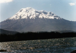
Mt. Everest is about nine kilometers above sea level and located about 28 degrees north of the equator. Chimborazo, the highest point in Ecuador, is seven kilometers above sea level and 1.5 degrees south of the equator.
So how far are Mt. Everest and Chimborazo from the center of the Earth? To answer that, we first need to how far sea level at latitude θ is from the center of the Earth.
Imagine slicing the Earth with a plane containing its polar diameter. To a good approximation (within 100 meters) the resulting shape would be an ellipse. The equation of this ellipse is
(x / a)2 + (y / b)2 = 1
where a = 6378.1 km is the equatorial radius and b = 6356.8 km is the polar radius. A line from the center of the ellipse to a point at latitude θ has equation y = tan(θ) x. Solving the pair of equations for x shows that the distance from the center to the point at latitude θ is
d = sqrt( a2b2 sec2 θ / (a2 tan2 θ + b2 ) )
For Mt. Everest, θ = 27.99 degrees and so d = 6373.4. For Chimborazo, θ = −1.486 degrees and so d = 6378.1. So sea level is 4.7 km higher at Chimborazo. Mt. Everest is 2.6 km taller, but the summit of Chimborazo is about 2.1 km farther away from the center of the Earth.
Update: See my next post for a slight correction. A more accurate calculation would compute sea level is about 4.65 km higher at Chimborazo than Mt. Everest.
Somewhat related, this reminds me of the following article I recently read: What would it be like walking around on a cube-shaped planet? (I can’t vouch for the accuracy of that article!)
John,
Thanks very much for this fascinating post!
Related, I am fond of the idea of spire measure as a measure of a peak’s magnitude, or “peakiness”. Perhaps it is because of my previous life analyzing FTIR spectra. I think the measure probably predicts better the feeling of being on top of the world when looking out from the peak on a clear day, but sadly I have no experience to assess it.
Ben,
I love thinking about situations such as you describe!
One of my favorite realizations when studying topology was that Asteroids is played on a torus (doughnut skin)! I’d say that the mapping of screen edges they (and many others) use is the most natural and intuitive, especially for a rectangular as opposed to a square screen, since the local metric is not an issue. I think it is also the most intuitive for the players, but I lack the distance from the subject that I’d like to be able to say for sure. But it is completely fascinating to me that this mapping which is so natural and intuitive actually forms a torus, and not a sphere as everyone assumes at first blush.
I’ve always wondered if there is an easy way to tell what the Euler characteristic of the universe is empirically. I suppose it should be a consequence of the Big Bang theory that it is 2, but I wonder if it is necessarily so. Speaking of Euler characteristics, perhaps the Asteroids torus is so natural because its Euler characteristic is zero.
Correction: If the universe is a sphere with a three dimensional surface, the Euler characteristic should be zero.
A small correction: Theta, as you specify it, is not the latitude. The latitude is conventionally defined as the angle between the normal to the geoid (essentially the surface defined by sea level) and the equatorial plane. This leads to a slightly different formula for distance from the center of the earth as a function of latitude. Your conclusions are unchanged because the correction to your expression is very small.
Isaac Asimov used to do this kind of thing a lot back in the 50s and 60s, before he got a word processor. It’s a lot of fun. Banks does something like this is in Slicing Pizzas, Racing Turtles. He shows that rivers like the Nile and the Mississippi run from a point closer to the center of the earth to a point farther.
Hello, I was told that the Cayambe volcano (height : 5.790 m) in Ecuador located on the equator line itself is higher than the Chimborazo volcano, located at 1.5 degrees south of the equator, measured from the center of the earth. Is that assertion a correct one, please? Thank you for your reply. Walter