A natural approach to mapping the Earth is to imagine a cylinder wrapped around the equator. Points on the Earth are mapped to points on the cylinder. Then split the cylinder so that it lies flat. There are several ways to do this, all known as cylindrical projections.
One way to make a cylindrical projection is to draw a lines from the center of the Earth through each point on the surface. Each point on the surface is then mapped to the place where the line intersects the cylinder. Another approach would be to make horizontal projections, mapping each point on Earth to the closest point on the cylinder. The Mercator projection is yet another approach.
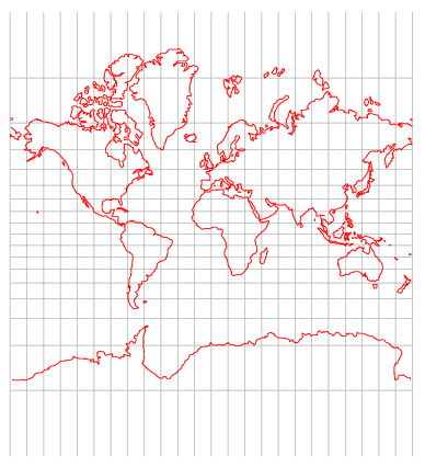
With any cylindrical projection parallels, lines of constant latitude, become horizontal lines on the map. Meridians, lines of constant longitude, become vertical lines on the map. Cylindrical projections differ in how the horizontal lines are spaced. Different projections are useful for different purposes. Mercator projection is designed so that lines of constant bearing on the Earth correspond to straight lines on the map. For example, the course of a ship sailing northeast is a straight line on the map. (Any cylindrical projection will represent a due north or due east course as a straight line, but only the Mercator projection represents intermediate bearings as straight lines.) Clearly a navigator would find Mercator’s map indispensable.
Latitude lines become increasingly far apart as you move toward the north or south pole on maps drawn with the Mercator projection. This is because the distances between latitude lines has to change to keep bearing lines straight. Mathematical details follow.
Think of two meridians running around the earth. The distance between these two meridians along a due east line depends on the latitude. The distance is greatest at the equator and becomes zero at the poles. In fact, the distance is proportional to cos(φ) where φ is the latitude. Since meridians correspond to straight lines on a map, east-west distances on the Earth are stretched by a factor of 1/cos(φ) = sec(φ) on the map.
Suppose you have a map that shows the real time position of a ship sailing east at some constant rate. The corresponding rate of change on the map is proportional to sec(φ). In order for lines of constant bearing to be straight on the map, the rate of change should also be proportional to sec(φ) as the ship sails north. That says the spacing between latitude lines has to change according to h(φ) where h‘(φ) = sec(φ). This means that h(φ) is the integral of sec(φ) which equals log |sec(φ) + tan(φ)|. The function h(φ) becomes unbounded as φ approaches ± 90°. This explains why the north and south poles are infinitely far away on a Mercator projection map and why the area of northern countries is exaggerated.
(Update: The inverse of the function h(φ) has some surprising properties. See Inverse Mercator projection.)
The modern explanation of Mercator’s projection uses logarithms and calculus, but Mercator came up with his projection in 1569 before logarithms or calculus had been discovered.
For more details of the Mercator projection, see Portraits of the Earth.
Thanks for this post. Mercator projection is a good example of “form follows function” — once you set out to have lines of constant bearing straight, this is what you end up with.
The political part lies in considering why/how this became the standard projection used for school wall maps. Schools aren’t on board ships, and navigation isn’t taught in grade school. One would think that the relative size of countries would be more important.
Here’s one of my favorites: equal-area, south at the top, centered on Australia:
http://odtmaps.com/detail.asp_Q_product_id_E_HDP-11×17
Sir–
There are many possible projections of polar regions, each maximizing their own criterion of importance. For example, Mercator is only useful if you are not navigating in the polar regions … The supposed “political controversy” to which you refer has predominantly been pushed by people who argue their own projection is superior to others, failing to acknowledge that utility of projections depend entirely upon your purpose. The common projections are acceptable to those who don’t know the difference between a loxodrome, a Wulff net, and a density equalization.
Maps have always been controversial, particularly to those who saw themselves in them rather than understanding them as tools. That’s why in part Nikola Kopernik, Galileo Galilei, and others got into so much trouble.
I find two aspects of the political controversy silly. First, some folks act as if the Mercator projection were created by Greenlanders anxious to exaggerate the importance of their country.
Second, the educational issue asks the wrong question: What one flat map should we use to teach geography? No flat map of a round planet is satisfactory. As ekzept said above, the “utility of projections depend entirely upon your purpose.” It would be good for schools to display two or three maps: polar projection, equal area, etc. But even better would be to put globes in classrooms.
Very much agree on globes … especially ones that depict all the undersea mountainous structure. I think this is one of those “economies” that schools do, somewhat like corporations eliminating technical libraries, or even access to libraries at universities.
Maps used to be a “killer app” in the days of the Medici and the like. Indeed, there’s one read of the development of the university which argues that patrons sponsored (and tolerated!) teachers (“professors”) because they needed somebody to teach the mathematics of navigation and surveying. There was a (somewhat tedious) PBS show The Shape of the World narrated by Patrick Stewart that addressed mapmaking and maps. One little thing I learned from that was that once upon a time, mapmaking was a treasured skill, so much so that competing interests would attempt assassinations of mapmakers to deprive capabilities.
BTW, some knowledge of spherical trigonometry and globes and such is IMO a litmus test of basic mathematical erudition. For instance, many programmers will, in my experience, look up a cookbook expression for calculating great circle distances along a spherical Earth model. If they are lucky, or wise to the ways of numerical calculation, they’ll get either the haversine relationship or one based upon unit vectors (my preferred), which are essentially the same. If they are unlucky, they’ll get the one which reads off the solution of the spherical triangle, code it up, and wonder why it doesn’t do well when points are close or polar.
There are a lot of interesting puzzles related to these. One I got involved with was the problem of drawing great and small circles on a Mercator projection and for the small circles working up the logic to shade the interior of the small circles appropriately. The tricky part (perhaps the only trick) is handling the ambiguity that on a Mercator that line along the periphery and across the poles is actually the same meridian.
This isn’t to pick only on some programmers. I once knew an aerospace engineer who believed you couldn’t navigate in polar regions because equations just went singular there. I was just out of school, and said “That’s completely silly. Of course you can.” I didn’t get heard, ’cause I was just a junior engineer. Clearly he should have known better, but it’s an example of when coordinate systems get a “life of their own”.
I can understand. Maxwell’s Equations are often taught in several forms, each form being peculiar to a commonplace coordinate system. I don’t know whether that’s a win or not, since there are a lot of problems having those settings. But the coordinate-free forms are the most insightful, I think. I learned coordinate-free vector systems relatively late in college, and I could never understand why they weren’t taught first.
” some knowledge of spherical trigonometry and globes and such is IMO a litmus test of basic mathematical erudition”
Anecdote: Some years ago I was sitting on my stationary bike and noticed I’d covered 12,500 miles, approximately half the circumference of the earth. In my boredom, I wondered what parallel had that circumference. Hint: it’s not the 45th parallel.
Being rusty on this stuff (I graduated high school in 1968), and having a set of school conferences to go to that evening, I decided to ask my daughter’s jr high math teacher whether I’d done this right. She said she’d check and get back to me. She didn’t and claimed she’d lost it. I sent another copy but didn’t get an answer.
I decided to try this on successive math teachers but they all — even the calculus teacher — ducked the question.
I tried this on bicycle mailing list and got me several replies, all correct, within a few minutes.
What? Is this a test? Assuming 25,000 miles is circumference of spherical Earth at Equator, ratio of circumference of small circle having normal parallel to the polar axis to that equatorial circumference is sine of 90 less latitude. Since 1/2 is the sine of 30 degrees, latitude is plus or minus 60 degrees. Yeah, sqrt(2)/2 is 0.707….
But maybe she just couldn’t be bothered, playing a game that no answer allowed her to keep all her winnings without risk.
Not a test; just an interesting thing to think about.
Not having given much thought to this question before sitting on the bike trying to avoid boredom, I was a bit surprised to find that the answer involved a parallel that passes through places I tended to think of as near the pole: Anchorage, far north Labrador, Cape Farewell in Greenland, Leningrad, north (and south!) Shetland Islands.
They aren’t near the pole, of course — no nearer in latitude than Chicago is to Panama City.
First, some folks act as if the Mercator projection were created by Greenlanders anxious to exaggerate the importance of their country.
It’s become far to easy to toss out the magic words “politically correct” as if that’s a logical argument for or against something. The *fact* is that the Mercatur Projection, intentionally or not, has been used to help perpetuate a lie; and not only that, it’s just plain not the *truth.*
Kids need to be taught how to *think,” not brainwashed with a map which misrepresents the relative size of their country and not only that, isn’t even accurate.
The Mercator projection is not a lie. It’s a projection. It doesn’t make claims about the relative sizes of countries anymore than it claims that the earth is flat.
I do think it could be misleading if the Mercator projection were the only map available. Classrooms should have globes. And students should be exposed to several projections so they learn that no projection is completely satisfying, that each has some desirable properties but that you can’t have it all at once when you map a sphere to a plane.
It would appear this derivation assumes the earth is a sphere, since the given definition of h(phi) depends solely on latitude and no spheroid parameters. It’d be good to clarify this in the article. For Mercator projection of a spheroid, see “Map Projection Equations” by Frederick Pearson II for a thorough treatment.