I saw a reference last night to the grid square EL29fx and wanted to figure out where that is. There are many programs that will do this for you, but I wanted to do it by hand.
I wrote about how grid squares work a year ago, but I was rusty on the details, so this morning I went back and reread my earlier post.
Parsing a locator
The system used to create grid squares in amateur radio is the Maidenhead Locator System. Last year I wrote about why the system works the way it does. Here I will recap how the system works but refer you to the earlier post for the motivation behind the design choices.
First of all, the Maidenhead system interleaves the longitude and latitude information. So in the square EL29fx, the longitude information is (E, 2, f) and the latitude information is (L, 9, x). The first two characters, EL, gives a rough location, a “field.” Then the next two characters, 29, refine the location to a “square.” The last two, fx, narrow the square down to a “subsquare.”[1]
Finding the field
The first character in the grid square specifies a range of longitude east of the International Date Line [2]. Each letter represents a range of 20° longitude: A for 0 to 20° longitude, B for 20° to 40°, etc. So E represents 80° to 100° longitude east of the antemeridian or 260° to 280° east of the prime meridian.
The second character in the grid square represents latitude north of the south pole in increments of 10°. So L represents 110° to 120° north of the south pole, or 20° to 30° north of the equator.
Together, EL tells us we’re looking at some place 260° to 280° E and 20° to 30° N, i.e. somewhere in Mexico or the US Gulf Coast.
Finding the square
The two digits in the middle of a grid square divide the field into 10 parts in both directions. Since a field is 20° wide and 10° tall, the first digit represents multiples of 2° longitude and the second digit represent multiples of 1° latitude.
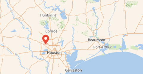
So if we look at EL29, we know our location is between 264° and 266° E and between 29° and 30° N, which is somewhere around Houston, Texas
Finding the subsquare
A subsquare divides a square into 24 parts in each direction. So a subsquare is 5 minutes of longitude wide and 2.5 minutes of latitude high.
The f in EL29fx refines the longitude is 264° 25′ E (95° 35′ W) and the x refines the latitude is 29° 55′ N. This narrows the location to somewhere in northwest Houston.
[1] There’s no significance to the case of the letters other than as a reminder that the first and second pair of letters are interpreted differently.
[2] Technically, degrees east of 180th meridian, a.k.a. the antemeridian, which mostly coincides with the International Date Line. The latter zigzags a little to avoid splitting island groups.
Thanks for this “out of the blue” example. Ten minutes ago. I’d never heard of grid squares, but now I can discuss them intelligently.
“All I know is that I know nothing.” – Socrates