Some kinds US Census geographic areas nest into a tidy hierarchy, but others do not. Here’s a brief overview of both.
Hierarchical entities
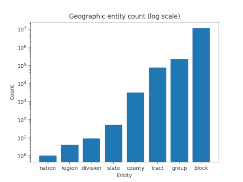
The orderly hierarchy is
- nation
- region
- division
- state
- county
- census tract
- block group
- census block.
All cleanly nested.
There are four regions: West, Midwest, Northeast, and South. Each region splits into two or three divisions. Each state falls within one division.
States are divided into counties, counties are divided into census tracts, census tracts are divided into block groups, block groups are divided into census blocks.
The number of entities at each level of the hierarchy is approximately geometrically increasing as show in the following log-scale bar graph. The number of entities at each level was based on the 2010 census.
Organic entities
The Postal Service cares how mail delivery points are clustered and doesn’t care so much for legal and administrative borders. For this reason, zip codes represent mail delivery points and not geographic regions per se.
Zip codes are subject to change, and can straddle county or even state lines. Zip codes make sense from the US Postal Service, and they are their codes after all. But the temptation to use zip codes as geographic areas is so great that it is often done, even though it results in occasional strange behavior.
The US Census does not use zip codes per se, but rather Zip Code Tabulation Areas (ZCTAs), which basically correspond to zip codes, but rationalize them a bit from the perspective of geography.
Urban Areas and Core Based Statistical Areas (CBSAs) are based around cities, and since for practical purposes a city can spread across state lines, Urban Areas and CBSAs can cross state lines. The organic growth of a city may cross state lines, even if legally the city is divided into two cities.
Census blocks
Census blocks accommodate both the hierarchical and organic geographic areas. That is, a census block is contained entirely within a block group (which is contained within a census tract, which is contained within a county, …) but also within a single ZCTA and a single CBSA.