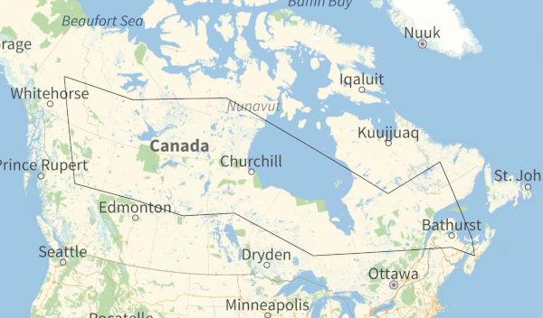
Here is a Traveling Salesman tour of Canada’s provinces and territories created by Mathematica. This is the shortest path connecting the geographic centers of the regions.
Here is a much larger (4.5 MB) PDF file of the same map with higher resolution.
Starting in the northwest, the tour is
- Yukon
- Northwest Territories
- Nunavut
- Quebec
- Newfoundland and Labrador
- Prince Edward Island
- Nova Scotia
- New Brunswick
- Ontario
- Manitoba
- Saskatchewan
- Alberta
- British Columbia
The tour is 11,070 km.
For more tours like this, see my earlier posts on tours of
Update: Here is an adjacency network for Canadian provinces and territories.

This is an SVG image so you can scale it to make it easier to read if you’d like.
More adjacency graph posts:
The adjacency graph for Canada shows that Nwefoundland and Labrador are only connected to Quebec (so one would need to go to Quebec twice: once to get to N&L and once to leave N&L). I was confused how the traveling salesman tour would work… then I reread the text more carefully and saw that the Canada tour is the “shortest path connecting the geographic centers of the regions.”
Thanks for your posts, John. I’ve been reading your blog for over a decade, and the content is always enjoyable.
The adjacency graph is interesting as it only seems to consider land joined together. You can drive from New Brunswick to PEI over the Confederation Bridge, and technically the Trans-Canada Highway connects Nova Scotia and Newfoundland with a ferry. Doesn’t invalidate it, just an interesting distinction.