How many trig functions are there?

How many basic trigonometric functions are there? I will present the arguments for 1, 3, 6, and at least 12.

The calculator answer: 3

A typical calculator has three trig functions if it has any: sine, cosine, and tangent. The other three that you may see — cosecant, secant, and cotangent — are the reciprocals of sine, cosine, and tangent respectively. Calculator designers expect you to push the cosine key followed by the reciprocal key if you want a secant, for example.

The calculus textbook answer: 6

The most popular answer to the number of basic trig functions may be six. Unlike calculator designers, calculus textbook authors find the cosecant, secant, and cotangent functions sufficiently useful to justify their inclusion as first-class trig functions.

The historical answer: At least 12

There are at least six more trigonometric functions that at one time were considered worth naming. These are versine, haversine, coversine, hacoversine, exsecant, and excosecant. All of these can be expressed simply in terms of more familiar trig functions. For example, versine(θ) = 2 sin2(θ/2) = 1 – cos(θ) and exsecant(θ) = sec(θ) – 1.

Why so many functions? One of the primary applications of trigonometry historically was navigation, and certain commonly used navigational formulas are stated most simply in terms of these archaic function names. For example, the law of haversines. Modern readers might ask why not just simplify everything down to sines and cosines. But when you’re calculating by hand using tables, every named function takes appreciable effort to evaluate. If a table simply combines two common operations into one function, it may be worthwhile.

These function names have a simple pattern. The “ha-” prefix means “half,” just as in “ha’penny.” The “ex-” prefix means “subtract 1.” The “co-” prefix means what it always means. (More on that below.) The “ver-” prefix means 1 minus the co-function.

Pointless exercise: How many distinct functions could you come up with using every combination of prefixes? The order of prefixes might matter in some cases but not in others.

The minimalist answer: 1

The opposite of the historical answer would be the minimalist answer. We don’t need secants, cosecants, and cotangents because they’re just reciprocals of sines, cosines, and tangents. And we don’t even need tangent because tan(θ) = sin(θ)/cos(θ). So we’re down to sine and cosine, but then we don’t really need cosine because cos(θ) = sin(π/2 – θ).

Not many people remember that the “co” in cosine means “complement.” The cosine of an angle θ is the sine of the complementary angle π/2 – θ. The same relationship holds for secant and cosecant, tangent and cotangent, and even versine and coversine.

By the way, understanding this complementary relationship makes calculus rules easier to remember. Let foo(θ) be a function whose derivative is bar(θ). Then the chain rule says that the derivative of foo(π/2 – θ) is -bar(π/2 – θ). In other words, if the derivative of foo is bar, the derivative of cofoo is negative cobar. Substitute your favorite trig function for “foo.” Note also that the “co-” function of a “co-” function is the original function. For example, co-cosine is sine.

The consultant answer: It depends

The number of trig functions you want to name depends on your application. From a theoretical view point, there’s only one trig function: all trig functions are simple variations on sine. But from a practical view point, it’s worthwhile to create names like tan(θ) for the function sin(θ)/sin(π/2 – θ). And if you’re a navigator crossing an ocean with books of trig tables and no calculator, it’s worthwhile working with haversines etc.

More trigonometry posts

Inverse Mercator projection

In my earlier post on the Mercator projection, I derived the function h(φ) that maps latitude on the Earth to vertical height on a map. The inverse of this function turns out to hold a few surprises.

The height y corresponding to a positive latitude φ is given by

h(φ) = log( sec(φ) + tan(φ) ).

The inverse function, h-1(y) = φ gives the latitude as a function of height. This function is called the “Gudermannian” after Christoph Gudermann and is abbreviated gd(y). Gudermann was the student of one famous mathematician, Karl Friedrich Gauss, and the teacher of another famous mathematician, Karl Weierstrass.

The Gudermannian function gd(y) can be reduced to familiar functions:

gd(y) = arctan( sinh(y) ) = 2 arctan( ey ) – π/2.

That doesn’t look very promising. But here’s the interesting part: the function gd forms a bridge between hyperbolic trig functions and ordinary trig functions.

sin( gd(x) ) = tanh(x)
tan( gd(x) ) = sinh(x)
cos( gd(x) ) = sech(x)
sec( gd(x) ) = cosh(x)
csc( gd(x) ) = coth(x)
cot( gd(x) ) = csch(x)

By definition, gd(x) is an angle θ whose tangent is sinh(x).

In the figure, tan(θ) = sinh(x). Since cosh2(x) – sinh2(x) = 1, the hypotenuse of the triangle is cosh(x). The identities above follow directly from the figure. For example, sin(θ) = sinh(x) / cosh(x) = tanh(x).

Finally, it is easy to show that gd is the inverse of the Mercator scale function h:

h( gd(x) ) = log( sec( gd(x) ) + tan( gd(x) ) ) = log( cosh(x) + sinh(x) ) = log( ex ) = x.

Related links

Mercator projection

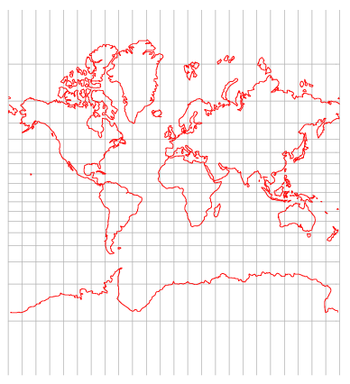
A natural approach to mapping the Earth is to imagine a cylinder wrapped around the equator. Points on the Earth are mapped to points on the cylinder. Then split the cylinder so that it lies flat. There are several ways to do this, all known as cylindrical projections.

One way to make a cylindrical projection is to draw a lines from the center of the Earth through each point on the surface. Each point on the surface is then mapped to the place where the line intersects the cylinder. Another approach would be to make horizontal projections, mapping each point on Earth to the closest point on the cylinder. The Mercator projection is yet another approach.

Mercator projection map

With any cylindrical projection parallels, lines of constant latitude, become horizontal lines on the map. Meridians, lines of constant longitude, become vertical lines on the map. Cylindrical projections differ in how the horizontal lines are spaced. Different projections are useful for different purposes. Mercator projection is designed so that lines of constant bearing on the Earth correspond to straight lines on the map. For example, the course of a ship sailing northeast is a straight line on the map. (Any cylindrical projection will represent a due north or due east course as a straight line, but only the Mercator projection represents intermediate bearings as straight lines.) Clearly a navigator would find Mercator’s map indispensable.

Latitude lines become increasingly far apart as you move toward the north or south pole on maps drawn with the Mercator projection. This is because the distances between latitude lines has to change to keep bearing lines straight. Mathematical details follow.

Think of two meridians running around the earth. The distance between these two meridians along a due east line depends on the latitude. The distance is greatest at the equator and becomes zero at the poles. In fact, the distance is proportional to cos(φ) where φ is the latitude. Since meridians correspond to straight lines on a map, east-west distances on the Earth are stretched by a factor of 1/cos(φ) = sec(φ) on the map.

Suppose you have a map that shows the real time position of a ship sailing east at some constant rate. The corresponding rate of change on the map is proportional to sec(φ). In order for lines of constant bearing to be straight on the map, the rate of change should also be proportional to sec(φ) as the ship sails north. That says the spacing between latitude lines has to change according to h(φ) where h‘(φ) = sec(φ). This means that h(φ) is the integral of sec(φ) which equals log |sec(φ) + tan(φ)|. The function h(φ) becomes unbounded as φ approaches ± 90°. This explains why the north and south poles are infinitely far away on a Mercator projection map and why the area of northern countries is exaggerated.

(Update: The inverse of the function h(φ) has some surprising properties. See Inverse Mercator projection.)

The modern explanation of Mercator’s projection uses logarithms and calculus, but Mercator came up with his projection in 1569 before logarithms or calculus had been discovered.

For more details of the Mercator projection, see Portraits of the Earth.

More geography posts

What is the shape of the Earth?

To first approximation, out planet is a sphere. But how accurate is that approximation? What’s a better approximation? How good is that? This post will answer these questions and some related questions.

How well does a sphere describe the Earth’s shape?

The Earth’s polar diameter is about 43 kilometers shorter than its equatorial diameter, a difference of about 0.3%.This is due to the equatorial bulge caused by the Earth’s rotation.

What’s a more accurate description of the Earth’s shape?

An oblate spheroid.

What is an oblate spheroid?

It’s the shape you get by spinning an ellipse around its minor axis. That says if you were to take a cross-section of the Earth containing the polar axis, the shape you get would be an ellipse. The polar axis would be the minor axis and the equatorial axis would be the major axis. But if you were to take a cross-section through the equator, or any plane parallel to the equator, you’d get a circle.

What is a prolate spheroid?

A prolate spheroid is what you get by spinning an ellipse around its major axis.

What is an ellipsoid?

An ellipsoid satisfies the following equation.

\left(\frac{x}{a}\right)^2 + \left(\frac{y}{b}\right)^2 + \left(\frac{z}{c}\right)^2 = 1

A sphere is an ellipsoid with a = b = c. An oblate spheroid is an ellipsoid with a = b > c. A prolate spheroid is an ellipsoid with a = b < c. A scalene ellipsoid is an ellipsoid for which a, b, and c are all distinct.

How good is the oblate spheroid model?

The error in approximating the Earth’s shape as an oblate spheroid is less than 100 meters, two orders of magnitude better than the spherical model.

How are other planets shaped?

The other planets in our solar system are also oblate spheroids with Saturn being the most oblate: the polar diameter of Saturn is about 10% shorter than its equatorial diameter.

More geodesy posts